This is not intended to be an exhaustive list, but provides a list of some of the better weather resources available.
Note: Some URLs change over time, please contact us to report problems..
This page is mainly intended for those who wish to determine if it will be cloudy during the evening (and thus interfere with astronomical observations). The simplest method is to locate the position of clouds on an infrared satellite image and extrapolate. This is fairly reliable if the difference between the satellite image time and the future event is a few hours, it is not very reliable for times of a day or so or longer.
To extrapolate the position of clouds, a good rule of thumb is to take the wind speed and direction at 500mb (meteorologists talk about conditions at various points in the atmosphere in terms of pressure, 500mb is approximately half the pressure of surface pressure). So if the infrared image shows clouds over Minnesota at 3PM, there could be clouds over Detroit at 10PM. However do not assume that wind speed and direction at the ground is the same as it is at 500mb.
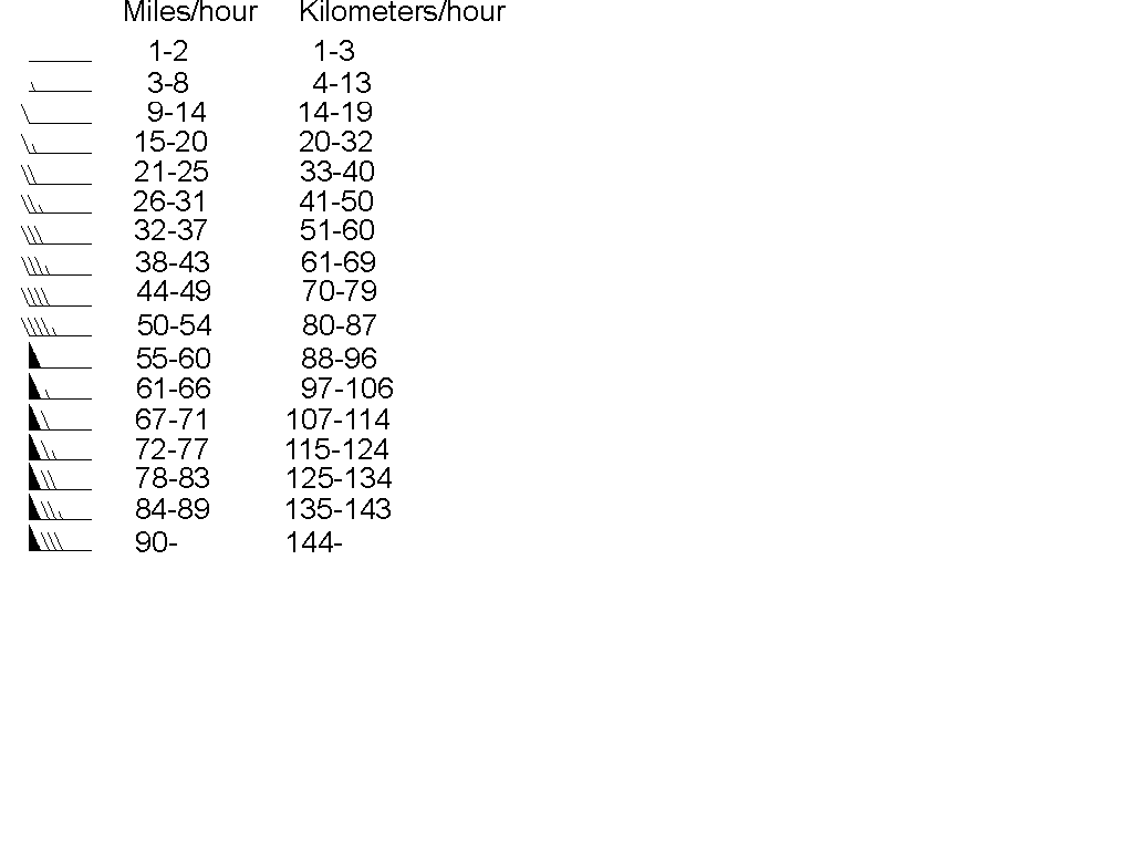
A 500mb chart shows the height of the 500mb surface, the temperature and wind speed/direction. At 500mb (but not at the ground), the wind follows the height contours. You can determine the wind speed by looking at the wind flags, the more teeth on the flag, the faster the wind. You can also estimate wind speed from the height contours: the closer the contours, the faster the wind.
However clouds can form or dissipate so this approach isn’t perfect. If the surface wind is from the Northwest or the West and there is a body of water to the Northwest or West, the air may pick up added moisture (this explains much of the cloudiness in Michigan). If the surface wind passes over a mountain, the air typically loses moisture, and the skies on the lee side (the downwind side of the mountain) tend to be clearer.
The tendency of clouds to form at a particular location can be determined by looking at a Stuve diagram. A Stuve diagram shows both the dew point and temperature as two lines, if these two lines are well separated then cloud formation is unlikely.
An alternative is to use the cloud forecast site(s) listed below.
The Clear
Sky Clock Homepage (forecast for Peach Mountain, Dexter Township, Michigan).
(http://cleardarksky.com/c/PeachMtObsMIkey.html?1)
The Clear Sky Clock Homepage
(forecast for other locations). (http://cleardarksky.com/csk/)
AOSS Weather Information. (http://weather.engin.umich.edu/)
The Weather Underground - Detroit, Michigan Forecast. (http://www.wunderground.com/forecasts/DTW.html)
AOSS Stuve Diagram for Detroit. (http://weather.engin.umich.edu/flash/stuve.html)
RAP Real-Time Weather Data. (The National Center for Atmospheric Research) (http://www.ral.ucar.edu/weather/)
National Weather Service. (http://www.nws.noaa.gov/)
Unisys Weather. (http://weather.unisys.com/)
Interactive Weather Satellite Imagery Viewers from NASA GHCC. (http://www.ghcc.msfc.nasa.gov/GOES/)
University of Michigan - WeatherNet. (http://cirrus.sprl.umich.edu/wxnet/)
The Weather Underground. (http://www.wunderground.com)
Todd Gross’ Weather & Astronomy Site. (http://weatherman.com/)
Unisys Weather - Upper Air Data. (http://weather.unisys.com/upper_air/index.html)
University Lowbrow Astronomers - Upper Air Map Legend (wind speed for each kind of flag).