Urban
Planning 525: Regional Planning (main page)
Fall
Semester, 2025
Prof Scott Campbell
Assignments and Grading
last updated Monday, November 24, 2025
|
Urban
Planning 525: Regional Planning (main page) Assignments and Gradinglast updated Monday, November 24, 2025 |
Students are expected to complete all the required readings before the start of class and be ready to actively participate in class discussions. Written assignments and presentations listed below. There will be no final exam. The work load (readings and paper assignments) is fairly evenly spaced throughout the semester. Please read these guidelines about writing, coursework and academic integrity
| No. | Assignment |
Due date |
individual or group task? |
Points (100 total) |
Format & how to submit |
in-class presentation? |
presentation materials uploaded to a shared google slide file? |
text file uploaded to Canvas? |
| 1 | group presentation (each student is a member of ONE presentation team)
|
your group will present on ONE of these dates: |
group |
25 |
in-class presentation (ca. 30-45 minutes, allowing for Q&A and discussion, or other interactive class activities you might design, for the rest of the 80 minute class session) |
yes |
Please upload your presentation slides to this shared class google drive folder (ideally as either a google slide file or a pdf, landscape format) |
|
| 2 | five response papers (5 pts each) -- see table below for scheduling details |
Sep 28, Oct 12, Oct 26, Nov 9, Nov 23 |
individual |
25 |
2 page text (double spaced; so ~400-500 words) uploaded to Canvas [remember to cite all sources, and put all outside text in quotes with a full citation] |
yes |
||
| 3 | Nov 20 (revised date) |
individual |
10 |
short (2 minute) in class presentation; images (appropriately labeled) and brief accompanying text -- uploaded to shared google slide file |
yes |
add map(s) to this shared google slide file |
||
| 4 | Dec 2 |
individual |
5 |
short (2 minute, in class) presentation, using 1-2 slides (uploaded to a shared google slide file) |
yes |
add slide(s) to this shared google slide file |
|
|
| 5 | Exam | Dec 4 (in class) | individual | 30 | in person (closed book/note/device) | |||
| Class Participation | throughout the semester | individual | 5 | Please attend all classes, do the required readings and come ready to class to discuss and engage the day's topics. |
Here are details about the modules, including presentations and short response papers:
Course Module (presentation date) |
Student Presentation Date |
Presenters (see this google doc signup sheet for the latest listing) |
Five Short Response Papers (2 pages each) |
0. History and Politics |
[no group presentation] |
[no group presentation] |
[no paper for this module] |
1. San Francisco Bay Area |
Sep 18 | [no group presentation] | Sep 28 |
2. Detroit & SE Michigan |
Sep 30 | Oct 12 |
|
3. New York City and the Tri-State area |
Oct 9 | Oct 26 |
|
4. Sunbelt regions (e.g., Los Angeles, Texas, Atlanta) |
Oct 28 | Nov 9 |
|
5. Ecoregions |
Nov 11 | Nov 23 |
|
6. Global/Comparative Regionalism |
Nov 25 | [no paper for this module] |
The class will divide into six presentation groups -- one for each module (no presentation for the "history and politics module").
![]()
![]() Group Formation will begin early in the semester, so please plan ahead and signup for ONE group on this google doc signup sheet
Group Formation will begin early in the semester, so please plan ahead and signup for ONE group on this google doc signup sheet
Please upload your presentation slides to this shared class google drive folder (ideally as either a google slide file of a pdf file, landscape format suitable for projection.)
The course is organized into modules, each on a specific theme. For each module, I will issue a question that relates to the course readings. Each student is to write an original response to the question. The goals of the assignment are to encourage all students to actively engage with the readings, to keep up with the weekly reading assignments, and to continuously relate the readings to major questions in regional planning. Late assignments result in point reductions.
1. San Francisco Bay Area (due Sunday, Sep 28)
Answer ONE of the following questions (see the above guidelines about the use of readings, citations, format, etc.)
The City and the Country: “Every city produces its own antithesis: a working, living, vibrant countryside. This is true in a double sense of an urbanized countryside and a ruralized city. We need to take account of both senses of the country in the city. On the one hand, the economic process of urbanization necessarily demands a countryside to service urban needs: farms, quarries, reservoirs, dumps, and the rest. The urban periphery is, in an important sense, a huge backyard of the city, and one that is fiercely exploited. That is the urbanized countryside.” (Walker, Richard A. 2009. Country in the City : The Greening of the San Francisco Bay Area. Seattle, WA, USA: University of Washington Press, p. 5) Regions typically contain a range of land uses and landscapes, from dense central cities, urban neighborhoods, inner and outer suburbs, farmland, open space, etc. And thus one way to view regional development planning is the management and regulation of this relationship and interplay (and often tension) between the city and the countryside (echoing Walker’s title). What is Walker’s understanding of the relationship between the city and the countryside (as seen in the SF Bay Area)? Does this lead to a new view of regional development?
An Environmental Leader? The San Francisco Bay Area has a reputation of being a leader in regional environmental efforts. Is this reputation deserved? Is it a model for other metropolitan regions? (In your answer, where appropriate, differentiate between various types of environmental efforts, from open space & habitat preservation, air and water quality, energy production and use, water use, recycling/composting, public transit, walking/bicycling; etc.)
Why is Bay Area Housing so Expensive and What can be done? The Bay Area has some of the most expensive housing in the country, leading to a housing affordability crisis, long commutes, stress on potential and current homeowners, and other challenges. What kinds of regional planning (and regional policy) tools have been used to address this crisis? What other tools might they try? Overall, should communities try to address the lack of affordable housing at the regional scale? (Or is it best done at the local, state and/or federal levels?)
The Region and Innovation: The Bay Area arguably has one of the most dynamic and profitable regional economies not just in the US, but in the world. Yes, there are big clusters of economic activity in the three biggest central cities (San Francisco, San Jose, Oakland), but much of the growth in new sectors (especially the tech sectors) happens outside these three cities. That is, we arguably need to speak about the regional economy, not individual city economies here. (Which differs from the old school language when we spoke of Pittsburgh as the center of steel, Detroit for cars, Akron for rubber/tires, Las Vegas for gambling, New York for finance, etc.). What are the economic advantages of developing and hosting tech sector firms not just in one or several cities, but rather in a larger regional context across many communities and counties? And do you think this region-wide, rather than city-specific, scale of the tech sector was intentionally and consciously planned (either by the public and/or private sectors), or did it just “emerge”?
The Role of the Bay: How has the central presence of the bay (a large tidal estuary with deep harbors) fundamentally shaped the area’s regional development and planning? (Not coincidentally, the region is known as the San Francisco Bay Area, or often just the "Bay Area, and not, say, the San Francisco Metropolitan Area or Greater San Francisco.) How has the role and perception of the bay changed over time? [One might speculate how the region would have developed differently had the bay not been there, but instead been a set of interconnected, low-lying valleys.]
From "the City" to the Region: Though historically the region has been focused on the City of San Francisco (as the region’s demographic, cultural and job center), the city occupies less than 1 percent of the Bay Area's total land area. Even in population, only about 10 percent of the total Bay Area residents live in San Francisco (with ca. 17% of the region’s jobs). (100 years ago, before massive suburbanization, this figure was about 50% of population and 67% jobs.) San José’s city population already exceeded that of San Francisco by the 1990 Census (though admittedly San José's land area is more than three times larger than San Francisco). And if one roughly estimates the larger “Silicon Valley” area population at approximately 2 to 3 million (a tricky task depending on how much of Santa Clara and San Mateo counties you include), then San Francisco’s once-dominant role in the region is further complicated.
Question: How would you describe the regional structure of the Bay Area? (e.g., mono-centric? Twin cities/dual core? polycentric? sprawling/decentralized/dispersed? conurbation? megaregion? Some combination of all of these?). What forces (either public and/or private) do you think have driven this geographic evolution over time?
BART and regional development: We spent some time in class on Sep 16 examining the history and evolution of the BART (Bay Area Rapid Transit) system since it was first conceived of in 1957 and opened for service in 1972. Do you see the system as a success, failure, a bit of both? Explain why. How do you think the existence of BART over the past 50+ years might have shifted the shape and direction of regional development? (e.g., had BART not existed, what then?).
2. Detroit & SE Michigan (due Sunday, Oct 12) [REVISED DEADLINE]
Answer ONE of the following questions (see the above guidelines about the use of readings, citations, format, etc.)
Weak Regionalism? Metro Detroit (aka SE Michigan) has a reputation for having weak regional planning. Is this reputation accurate? What are the primary explanations found in the readings? Do you find these explanations convincing? What explanation might the readings overlook?
Transportation as the Key Element of Regionalism? Regionalism has many dimensions (economic, cultural, environmental, etc.), and a multi-faceted regional planning effort can (or should) include a wide range of projects, programs and policies. Yet promoting strong transportation infrastructure is often a primary focus of regional efforts. Some might even argue that the quality of a region’s transportation system is a barometer of its overall ability to promote and manage its regional development. (i.e., a strong, integrated regional transit system ≈ a strong, integrated region). If this relationship is true, what does the state of SE Michigan’s transportation system say about the region? To answer this question, you might identify several features of SE Michigan’s transportation system and use these as indicators or proxies of the nature of regional planning/coordination/governance in SE Michigan. (Note: you could focus on a range of features, such as the geography of the network, financing, use/ridership, administration (including local vs. county vs. regional agencies), level of inter-jurisdictional cooperation, etc. And on freight or passenger networks; public transit or private vehicles; rail or bus; etc.).
The Role of the Southeast Michigan Council of Governments: How do you view and evaluate the role of SEMCOG in the region? For example, is it a strong or weak institution? Does it have much power? How does it compare to similar agencies in other regions (such as ABAG and MTC in the San Francisco Bay Area)? Do you have optimism that the agency could become more proactive and influential in the future (e.g., to promote greater equality between Detroit and suburbs? to promote stronger mass transit? to pursue regional climate change goals? etc.). If there was a job listing at SEMCOG, would you apply?
Explaining SE Michigan's Region to Visitors: Imagine that a group of international planning students is planning a visit to Detroit to understand American regional development, city-suburb relationships, the geography of American racial politics, and the peculiar/exceptional nature of metropolitan development in America in general (and Detroit specifically). Prepare a concise memo/overview that provides these students with a clear and useful explanation of the most important elements and explanations of the Southeast Michigan’s regional characteristics. What short list of readings would you recommend (to have them read on their overseas flight to DTW)? Optional additional element: if you were to organize a half (or full) day bus tour of the region, what would you show them (and how would this route & stops illustrate the region’s key dynamics)? [Note: if it would help you visualize your visitors and focus your task, you might imagine that the students are all coming from a specific country, e.g., Germany, Ghana, Brazil, China, etc.]
The Regional Consequences of the Hollowed Out Central City (the "donut city"): The city of Detroit’s population peaked in 1950. It has since lost roughly two-thirds of its population, as jobs, people, retail, etc. have moved from the city to the suburbs (and beyond). Socio-economic data shows that the region’s housing markets, household income, public infrastructure, school quality, etc. are higher in the suburbs than in the city of Detroit. Can a regional economy thrive if the central city is struggling? That is, to what extent is a healthy, strong regional economy dependent on a strong central city? And if Detroit’s problems hold back the development of its suburbs, why don’t the various suburban communities and counties (e.g., Oakland, Macomb, Washtenaw, Livingston, St. Clair and Monroe counties) come together to promote Detroit’s revitalization?
3. New York City and the Tri-State area (Oct 26) [REVISED DEADLINE]
Answer ONE of the following questions (see the above guidelines about the use of readings, citations, format, etc.)
Regionalism vs. Localism: A leitmotif of this course is the advantages of regional coordination and planning to overcome myopic localism, fragmentation and inequality. Yet an apparent sub-current of Benjamin and Nathan's analysis is the downside of regionalism, and the loss of important local activities when the scale of government gets too large (even when a city itself, such as New York, gets too large). In your essay, articulate and then critique the authors' view of regionalism vs. localism. How does regional governance in the New York region either respect and/or undermine positive local government and governance?
Equity Planning at the Regional Scale? Benjamin and Nathan (2001) note that "equity arguments to promote collaboration -- urging fairness between races and classes -- rarely work" [p. 30]. They go on to argue that "social equity is best advanced as a by-product of regional reform, not as its social focus" [p. 32]. In your essay, examine how the authors use the various case studies in the New York region to support this argument. Do you agree or disagree with their conclusion? Explain why.
The RPAA: The Regional Plan Association has developed four plans for the New York region over the last 90+ years, each one reflecting its era's distinctive planning traditions, ideologies and challenges to the region. Select at least two plans and use them as a framework to analyze how the New York region and approaches to regional development have changed over time.
The Port Authority as Regional Planning? The Port Authority of New York and New Jersey is a large and powerful organization that controls key infrastructure and properties at the regional scale. To what extent should it be considered a tacit regional planning authority (by another name)? Discuss to what extent the activities of the Port Authority constitute "regional planning" (which, in turn, requires you to provide a concise set of criteria of what you think regional planning is). Finally, is the PANYNJ a model of regional planning that should (or could) be reproduced in other parts of the US?
Multi-state Regions: The greater New York metro region extends into three states (hence the “Tri-State region”). How does this multi-state political geography shape the dynamics of regional planning in the region? What distinctive problems arise in regional planning that crosses state boundaries, and what kinds of solutions/workarounds have been developed to engage these challenges? Are there any advantages of this situation?
New York as a Model or as a One-Off? How much (or little) can other US metropolitan regions learn from the case of New York metropolitan regional planning and development? On the one hand, the region has been the origin / test case of many early theories and experiments in regionalism and regional planning; it has perhaps the longest-running and best known non-profits engaged in regional planning advocacy (the RPA); the model of the Port Authority as regional infrastructure cooperation; and the most extensive network of local and regional public transit. And yet the region is exceptional in so many ways that a direct translation of its regional strategies to smaller US regions may seem inappropriate. How do other regions learn from the successes (and failures) of the New York region?
4. Sunbelt regions (e.g., Los Angeles, Texas, Atlanta) (Nov 9) [REVISED DEADLINE]
Sunbelt Regionalism? Can one speak of a “Sunbelt Regionalism"? Do the patterns and politics of either regional development and/or regional planning in the Sunbelt regions differ in substantive ways from the regionalism found in eastern and Midwestern metropolitan areas? If so, what might explain these differences? (To help focus your answer, you might pick a few metro examples, and focus on one or more topics, such as land use, transportation, natural resource management, growth control & sprawl, social inequality, the strength or weakness of regional institutions, etc.)
Comparing two Sunbelt regions: Pick two Sunbelt metro areas (e.g., Los Angeles, Atlanta, part or all of the Texas Triangle, a region in Florida, etc.) and compare the central themes and challenges of regional planning and coordination. What factors might explain the critical similarities or differences between these two regions?
Two divergent theories of regional development? Some of the fastest growing metropolitan areas (by population size) are located in the South, Southwest and West. (Selected 2010-2020 US Census population growth: Austin-Round Rock-Georgetown, TX MSA: 33.0%; Orlando-Kissimmee-Sanford, FL MSA: 25.2%; Raleigh-Cary, NC MSA: 25.1%; Phoenix-Mesa-Chandler, AZ MSA: 15.6%; Atlanta-Sandy Springs-Alpharetta, GA MSA: 15.2%). Many older metro areas in the Northeast and Midwest grew far slower (e.g., New York-Newark-Jersey City, NY-NJ-PA MSA: 6.6%; Philadelphia-Camden-Wilmington, PA-NJ-DE-MD MSA: 4.7%; Detroit–Warren–Dearborn, MI MSA: 2.2%; Chicago-Naperville-Elgin, IL-IN-WI MSA: 1.7%). Do we need two theories of regional development (and perhaps two different approaches to regional planning): one for fast growing regions and one for slow growth regions? (As with Question 1, you might pick a few metro examples, and focus on one or more topics, such as land use, transportation, natural resource management, growth control & sprawl, social inequality, etc.)
Multiple Sunbelts? California was once arguably the most important example of rapid Sunbelt growth, with dramatic growth during the second half of the 20th Century, surpassing New York State in the 1960s as the most populous state in the US. And the Los Angeles metro area was the epicenter of this rapid California expansion (and in a way the model of a new type of city and region, more dynamic and relevant than the older metro areas of New York, Chicago, Philadelphia, or Detroit). But by the end of the 20th century, the growth of California slowed, and other metro areas of the “Sunbelt” saw accelerated growth, such as in Texas (Dallas, Houston, Austin), Arizona (Phoenix, Tucson), Florida (Miami, Orlando, Tampa), and Georgia (Atlanta). Perhaps Sunbelt urbanization, like other forms of urbanization, has a “life cycle”: an initial boom, maturation, and possible stagnation (and/or revitalization). If we can no longer accurately speak about Sunbelt urbanization a monolithic process, do we need to now talk about multiple eras or variations of Sunbelt growth?
5. Environmentalism, Sustainability and Natural Resources at the Regional Scale (Sunday, Nov 23)
Answer ONE of the following questions (see the above guidelines about the use of readings, citations, format, etc.)
(Re)defining ecoregions: One might define (and map) an ecoregion using various criteria: watersheds/drainage basins; ecological zones (e.g., based on animal and plant communities); agricultural zones (e.g., using the USDA Plant Hardiness Zone Map); just to name a few. In your essay, discuss the power (and limitations) of the concept of the ecoregion and the various ways one might define and map it. Do you find the “ecoregion” (e.g., as concept, as map, as set of criteria, as ethos) useful or not? Explain. [Note/mea culpa: I have been using the terms ecoregion and bioregion in an interchangeable way — and likely are conflating two distinct terms in a way that ecologists, conservation biologists, etc. would find imprecise or problematic. Sometimes I simply have used “ecoregionalism” to refer to an emphasis on ecological systems and environmental efforts (rather than economic, infrastructural or social priorities) done at the regional — as opposed to local or national — scale. Feel free to substitute and/or redefine terms for your essay, such as ecoregion, bioregion, ecosystem.]
Regional Strategies: Identify at least two potential strategies/tools/planning policies (real or potential) to promote greater sustainability and/or to combat climate change at the regional scale. Explain how these strategies work and explore their strengths and limitations. [Notes: (1) These might be strategies that can only work at the regional scale, not the local or national scales — or strategies that can work at many geographic scales but arguably work particularly well at the regional scale. (2) These strategies can be already in practice, such as greenbelts/urban growth boundaries; regional rail networks; urban conservation land trusts; etc., or strategies that are still proposed, speculative or aspirational.]
Regional environmental justice? Advocates of regionalism have long promoted the potential (sometimes real, sometimes elusive) of the regional perspective to both acknowledge social inequality (whether the centuries’ old inequality between rural agricultural landscapes and urban industrial & commercial centers, or the inequalities between middle-class suburban enclaves and struggling post-industrial urban communities) and the potential of regional-scale planning and governance to promote social justice. These past two weeks we have turned to the topic of regions, natural resources, environmental sustainability and climate change. In your short essay, examine the connections (existing and/or potential) between regionalism and environmental justice. Does the idea of “regional environmental justice” carry weight and meaning?
Water, Regions and Sustainability: The path towards more sustainable communities arguably requires changes in ways that regions extract, use, distribute and conserve a range of natural resources: air, land, energy, minerals, flora, fauna, water, etc. Is water unique in this list? Examine the distinctiveness of water as a natural resource and the resulting form/dynamics of water resource policies and politics/conflicts. That is, how is water different from other natural resources, and what implications do these specific characteristics of water resources have on shaping a sustainable water resource strategy at the regional level?
Turning an MPO green? Scenario: You work for an MPO, which focuses mostly on transportation projects (plus providing regional data analysis and forecasts). Your boss comes back from a conference on sustainability, climate change and eco-regionalism and excitedly wants to elevate ecological principles and priorities in the MPO's work. (Your boss senses that there might be something distinctive and powerful about the regional dimension of sustainability, but doesn’t know exactly what this may be and whether it is true.) Your boss tasks you with writing a 2- or 3-page memo on the specific role of the regional scale (and regional planning and coordination) in promoting sustainable development. Write this memo. (If it helps, you might pick one region or MPO to give memo task greater specificity.)
Climate Migration's Impact on US Regional Change: Migration researchers often differentiate not just between domestic and international migration, but also between intra-regional (within a region, e.g., city to suburb) and interregional migration (e.g., from the US Midwest to the Southwest US). (That is, classifying migration by distance traveled and the administrative or geographic boundaries crossed.) In our examination this semester of various US regions, we have seen how interregional migration — as well as international migration from other countries to the US — have been a key factor in either regional robust growth (e.g., the US South and West) or relative decline (e.g., the industrial Midwest). Some have optimistically predicted that climate change might reverse this migration pattern in the future, making the Sunbelt less appealing and such areas as Michigan and the Great Lakes a more attractive destination (i.e., a “climate haven”). Referring to the recent research and literature on “climate migration,” (e.g., the readings suggested in the syllabus for Nov 6), do you see a consensus emerging about climate change’s impact on interregional migration within the US, or is there too variation, disagreement and/or uncertainty in research so far?
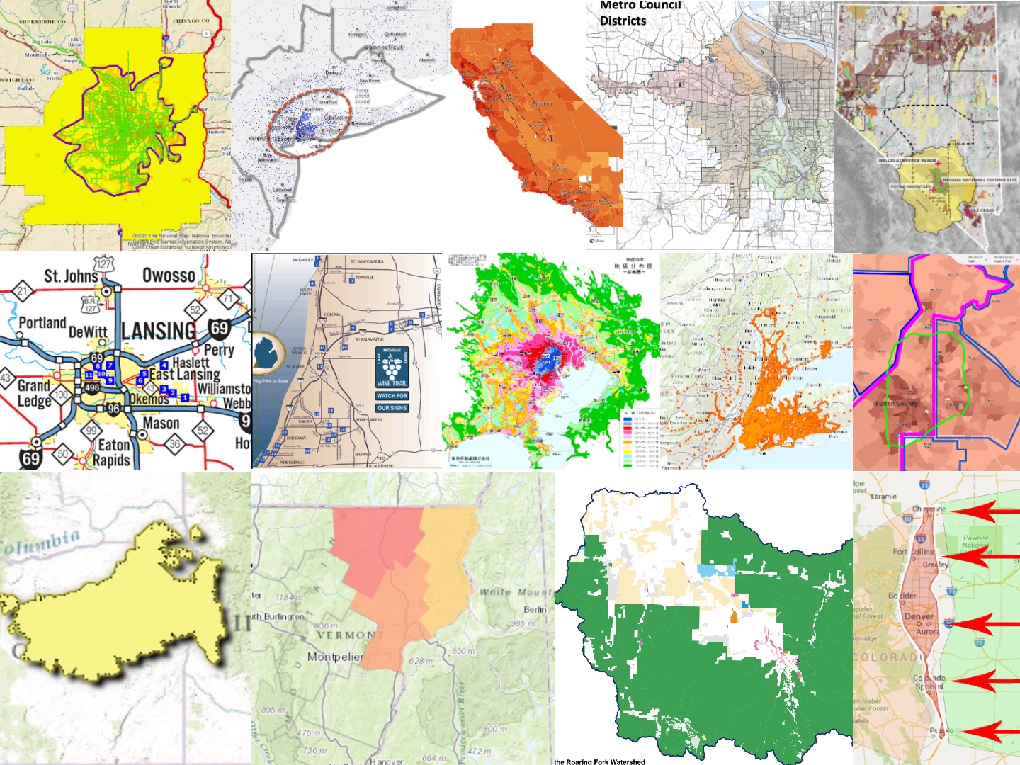
The goal of this first assignment is to explore the varied ways to understand a region: its definition, delineation and internal structure. Various questions arise: What differentiates a region from a city and from a state? How do ecologic, economic, administrative and social criteria lead to differing boundaries of a region? This is less a cartographic exercise per se, but rather an exploratory, pow-stakes exercise to understand the conception of a region using the process of mapping of a region (e.g., the growing Atlanta metro area; the Bos-Wash mega region; etc.). The goal is to think more explicitly about the definitions and delineations of a "region" — and how the view (and boundaries) of a region might vary if viewed by an ecologist, a hydrologist, a labor economist, a political scientist, a transportation planner, etc.
![]() REQUEST: As you work on this assignment, please fill out this informal questionnaire about your selected region.
REQUEST: As you work on this assignment, please fill out this informal questionnaire about your selected region.
Here are some themes, questions, elements that may arise:
This penultimate session will provide an opportunity to reflect on the course, and develop a set of conclusions and/or principles about regional planning.
TASK: Each student is to prepare a concise, insightful distillation of what have been, for you, the most important or resonant (or disconcerting) lessons/principles/ideas/themes in your encounters with regionalism, regional development and regional planning. I welcome a range of approaches and themes, and I encourage you to be rigorous and creative.
You are to prepare several items:
(a) a brief (3-4 minute) oral presentation that concisely highlights your central points.
(b)
For this presentation, prepare a slide to be shared with the class on this add slide(s) to this shared google slide file
[NOTE: one slide will do, but if you find it easier to present your materials on two slides, that is also an option.] Consider various formats, including diagrams, maps, tables, illustrations, a concept map, a flow chart, a numbered list.,a storyboard, a comic strip, a Socratic dialogue. Use supplementary text where appropriate to elaborate specific ideas/points.
We can use the remaining time to answer any questions you might have about the exam on Thursday, Dec. 4.
This will be an in-class exam, held during the final course session.
Format:
![]()
![]() See the Key Concepts, Questions, Themes on the course overview page (which can serve as a useful study guide)
See the Key Concepts, Questions, Themes on the course overview page (which can serve as a useful study guide)