

|
|
last modified: Saturday, December 17, 2005 3:54 PM |
|
Economic Development and GIS |
|
Amanda M. Goski |
gamanda@umich.edu |
Communities are constantly in competition with one another to attract businesses. New and better ways to market a community constantly go through experimentation. One tool that has come to the forefront is the use of a geographic information system (GIS). Lately, more and more communities are adopting this tool for land use planning and for economic development planning.
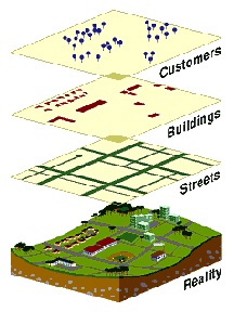
GIS is a tool that allows people to visualize issues geographically. Information is linked in the form of a data table to a variety of features such as points, lines, and polygons, when combined, result in a map. However, the data can also be used to create graphs and models. Data can be added to and modified over time and is accessible with the click of a button. Distance between objects can be observed as well as spatial patterns, quantities, or barriers that were not noticed just by looking at the information in paragraph or numeric form. After a person visualizes the information in this new way, it is then possible to make decisions or adjust the information to include hypothetical situations. Example: Determining if there is a relationship between forest area and the lifespan of squirrels, or determining if there is something in the southern area of the map affecting the squirrel population (perhaps industrial waste…).
Image Source: Rockville City Government,
http://www.rockvillemd.gov/gis/
Foremost, GIS is not a new concept for use in the public sector (Schmitz, 1995; Perlman, 2000). The Federal Government, particularly the Department of Defense, has used the technology for decades. Counties started using GIS in the 1980s to map out land use and engineering data. More recently, local governments began implementing their own GIS. Information such as land use, property lines, sanitary, sewer, tax information, ownership, roads, railways, zoning, and other property information have been included in the databases (Schmitz, 1995; Perlman, 2000; The American City and County, 1998; ESRI, 2001, 2005).
While not originally seen as a tool for community economic development, GIS is quickly becoming an extremely desired technology for municipalities to offer. Although tax breaks and other incentives are the standard means for attracting new businesses, interactive GIS is a stronger marketing tool (The American City and County, 1998). Making the decision to relocate a business or start a business in a community, especially communities in areas firms are unfamiliar with, is an extremely risky and costly venture. Communities are now able to offer interactive GIS that enables businesses to virtually tour the area. Hyperlinks provide access to pictures and video clips. Software, like Business Analyst (ESRI, 2001; 2005), give businesses access to information about competitors, complimentary businesses, demographics, and consumer projections (Schmitz, 1995; Perlman, 2000; The American City and County, 1998; ESRI, 2001, 2005; Doyle, 2002). Municipalities can more efficiently and effectively assist businesses in their location decisions (Doyle, 2002; The American City and County, 1998; Perlman, 2000; Schmitz, 1995).
Another tool for economic development planning that uses GIS is modeling and spatial analysis. Building footprints can be mapped out. District boundaries for business improvement districts, TIF districts, historic districts, and downtowns are mapped. Within the GIS revenue from taxing parcels is calculated, along with how the numbers are affected if the boundaries were expanded or decreased. Virtual cities are at the fingertips of government officials. GIS assists in spotting problematic areas and using this information to create solutions. For example, school districts boundaries can be redrawn to include a more diverse group of students or an equal number of students. Private firms such as Vierbicher Associates use GIS to help communities assess their downtowns and come up with an action plan, as is the case of Whitewater, WI (2005).
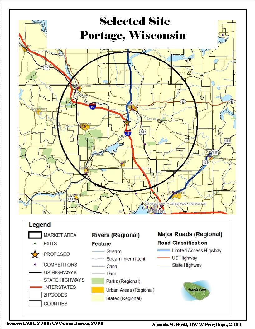
If GIS is so great, then why are there still communities not using this technology? For starters, to create a GIS there is an extremely high start-up cost, and municipalities are on very tight budgets. Employees with the working knowledge and capabilities are hard to find. Collecting data is both time consuming and costly, and making sure data is accurate is crucial (Doyle, 2002). Also, GIS is difficult for many people to learn, and even if the data is available, businesses need assistance with utilizing it (Perlman, 2000). Despite its high start up costs there are many benefits to employing this technology. GIS reduces the amount of time spent on long daunting tasks. This allows time to be spent doing other tasks, and it saves municipalities money because more employees do not need to be hired (Schmitz, 1995; Perlman, 2000). Finding people who are familiar with GIS is also becoming easier because of growth of the industry and universities now offer introductory courses and certification programs. For instance, the Portage, Wisconsin map was created as a project for an Economic Geography class at the University of Wisconsin-Whitewater during the 2003-04 school year. The point of the assignment was to pick a location along an Interstate exit and determine whether the site would be appropriate for a new restaurant based on a multitude of factors. Exercises such as this occur all the time using GIS and Economic Development.
Overall, the consensus has been implementing a GIS for a community pays for itself in a relatively short amount of time (Schmitz, 1995). If communities want to stay competitive in attracting new businesses, they will need to invest in a GIS. Businesses able to go to a community’s website and browse properties will seriously consider these municipalities. Communities can also use the technology to easily identify underutilized properties, vacant parcels, industry clusters, blighted areas, and more.
Communities thinking of creating their own GIS can start by looking at the following list of resources for more information:
Additional resources:
Examples of Communities using GIS
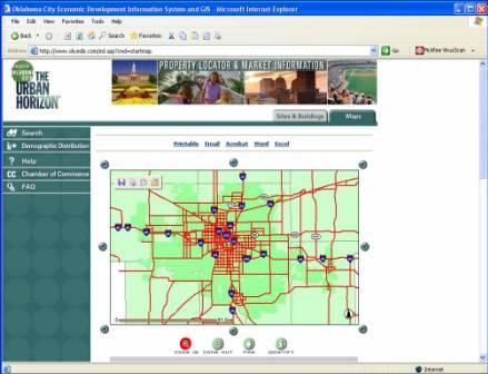
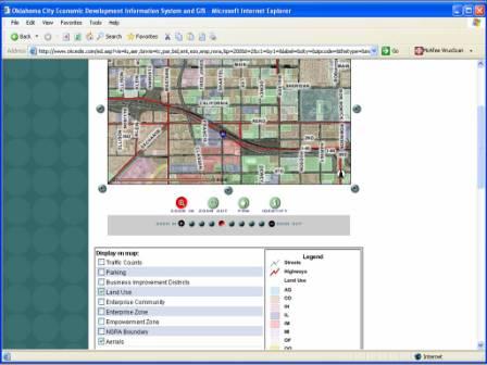
Source: Oklahoma City Economic Development Information System and GIS
http://www.okcedis.com/ed.asp?cmd=startmap
Doyle, Z. (2002). GIS As a Tool to Promote Economic Development. Economic
Development Digest. Accessed on 21 Oct., 2005 from http://www.nado.org/pubs/nov025.html.
ESRI. (2001). GIS Solutions for Economic Development. ESRI - The GIS Software
Leader. Accessed 21 Oct., 2005 from http://www.esri.com/library/brochures/pdfs/gis-sols-for-ecodev.pdf
Perlman, E. (2000). Focus on Geographic Information Systems: Maps That Sell. Governing
Magazine. Congressional Quarterly, Inc. Washington, D.C.
Rockville City Government. (2005). Geographic Information System. Accessed
on 25 Oct, 2005 from http://www.rockvillemd.gov/gis/.
Schmitz, B. (1995). Pushing the GIS envelope. Planning. Chicago, 61(7),
12. from ProQuest Search Engine.
Vierbicher Associates. (2005). City of Whitewater Action Plan for Downtown
Revitalization. City of Whitewater Webpage. Accessed on 12 Nov., 2005
from http://www.ci.whitewater.wi.us/Press_Releases/Action%20Plan%20-%20Final.pdf.